![]()
Exploring Kenya's Rift Valley Lakes
Vacationtechnician personalized luxury adventure travel transports you to the most exquisite wilderness and chill out retreats on Earth. Conserving rare biodiversity through low volume tourism; our aim is your indulgence -at no one's expense. Plan now to be assured a rejuvenating escape at a restful pace -to an unspoilt gem in the purest sense.
Approaching by air from Europe, the first glow of day reveals the convoluted folds of a worn and rumpled carpet. Below, a long and narrow crease runs irregularly down the length of the African tapestry to form the Rift Valley. Where the fabric in the crease has worn through, irregular patches of water form the many lakes of the African Rift, the ridges the high mountains. Flying through the rarefied atmosphere of pre-dawn, the first hint of Kenyan territory is a sliver of light refracted by Lake Turkana in the northern desert.
Africa's Rift Valley carves a 6 000-kilometre trench down the length of the continent. Varying in width from 50 to 90 kilometers, this long tear in the earth's crust is visible from 150 000 kilometers out in space. Dormant volcanoes punctuate the flat floor of the valley, and a chain of lakes - some fresh and others bitter - flood the deep depressions. Seven of the Rift lakes are found in Kenya, each one distinct from the next.
LAKE NAIVASHA
Lake Naivasha is a freshwater lake, encircled by the high wall of the Rift
to the east and the Mau escarpment to the west. It is also the lake occurring
at the highest altitude - 1 910 meters. The water body closest to Nairobi,
the lake is now the centre of an area of a prosperous flower export business,
but much of its charm and wildlife have been preserved. Aside from the flower
estates, dense stands of fever trees Acacia xanthophloea form the dominant
vegetation type. On the commercial ranches adjoining the lake, herds of Kenyan
giraffe, plains zebra, impala, kongoni antelope and Thomson's gazelle are
common. Although crocodiles are not present, hippos still occur and buffalo
frequent the swamps on the lake's northern edge.
Joy Adamson's house, Elsamere, which is situated on the southern shore, is now run as a conservation centre and contains original paintings of the lion, Elsa, and other works by Adamson. I was particularly interested in the resident troop of Abyssinian black-and-white colobus monkeys Colobus abyssinicus, a primate normally associated with dense highland forest.
South of the lake, Hell's Gate National Park encompasses 68 km2 of a rugged tear in the Rift wall. Fischer's Tower, near the entrance, is a lone 25-metre-high volcanic plug. It is thought that the gorge once served as an ancient outlet for Lake Naivasha. Apart from its rugged scenery, Hell's Gate supports a variety of wildlife including baboon, eland, kongoni, gazelle, cheetah and leopard, while many raptors nest on the rocky cliffs of the gorge.
On the southern shore, the dormant volcano Longonot rises to a lofty 2 776-metre summit that encloses a perfect volcano; a spectacular, bush-filled crater occupies the mountain's inner realm. A 52 km2 national park has been created around the peak.
LAKE NAKURU
The most famous of Kenya's Rift lakes is undoubtedly Nakuru, one
of the finest bird-watching destinations in the world. The first national
park in Africa dedicated to the conservation of birds was established here
in 1961. Originally the park consisted of a 46 km2 sanctuary covering the
southern two-thirds of the lake. In 1974 additional purchases, supported by
the World Wildlife Fund, included land to the north, and a large patch of
acacia woodland and escarpment south of the lake. The park now covers 188
km2, and although it is small by African standards, it nevertheless remains
one of Kenya's finest national parks.
The main approach to the park leads through Nakuru's drab southern suburbs to the lake's northern shore. At the entrance gate (and the electric fence that surrounds the park), the contrast is sudden. Tall fever trees frame the entrance and olive baboons feed in the clearings. Down the lakeshore with its fish-factory smell of flamingo guano and alkaline water, nearly 1.5 million lesser flamingos’ parade in mass displays of pink plumage.
Lesser flamingos feed on blue-green spirulina algae and diatoms that thrive in the warm, alkaline water. Greater flamingos are less common and feed on crustaceans and invertebrates that live in the lake bottom mud.
Although it is the concentration of flamingos - often referred to as 'the greatest ornithological spectacle on earth' - that attracts the most attention, a number of other species are common. The introduction in 1960 of the salt-tolerant fish Tilapia grahami in a bid to control mosquitoes has attracted large numbers of pelicans, cormorants, herons and other water birds. More than 400 bird species and 50 mammal species have been recorded at Nakuru.
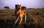
Despite the close proximity of Kenya's fourth largest city and densely populated agricultural land, Lake Nakuru is a prime wildlife area. The park is surrounded by an electric fence, erected to protect some 35 black rhino and a recent introduction of 10 white rhino from South Africa. In 1977 a herd of rare Baringo giraffe from western Kenya was introduced. The herd has increased and the giraffe are now often encountered. Along the grasslands bordering the lake, herds of buffalo, impala, bohor reedbuck, and defassa waterbuck are common. Near the southern edge of the lake we encountered a young leopard lying on the side of the road. Scarcely two kilometers further we came across two lionesses walking through the golden grassland along the lakeshore. On the opposite side of the road two cheetahs rested a short distance away, and in the distance a small herd of white rhino emerged from an acacia thicket.
On the southern shore, the dense stands of fever trees are worth exploring, particularly for views of the black-and-white colobus monkeys and the crowned eagle. On the eastern shore a thicket of the tree euphorbia Euphorbia candelabrum is the only one found in Kenya.
We left the park through the north-eastern Lanet Gate and were soon driving past spacious houses that now occupy plots of land on the outskirts of Nakuru. For a few hours the illusion of a wilderness unaffected by humans had been complete. It was hard to believe that leopards, lions and black rhino inhabited the land just a few hundred meters behind us. I was left with the strong realization that, like it or not, all Africa's national parks will eventually become islands whose survival will be inseparably linked to the application of skilful management decisions regarding both the animals and the people who come to see them, and effective neighbor relations policies.
LAKE BOGORIA
Some 60 kilometers north and in a hot, low-lying region of the Rift, Lake
Bogoria is the most dramatic of the central lakes. A narrow tarred road leads
through arid acacia country to the northern entrance to the national reserve
that surrounds the lake. Unlike nearby Baringo there is no hint of the lake
until the reserve entrance is reached. Then the scenery dramatically unfurls
to reveal the lake. The Rift wall rises in a near-vertical escarpment on the
eastern shore to a height of 630 meters above the flamingo-dappled lake. During
a visit in 1893, Bogoria's stunning scenery was described by the geologist
John Gregory as 'the most beautiful sight in Africa'.
Halfway down the track that leads along the western shore, several hot springs
gush to the surface. The boiling water in the springs originates from water
that is super-heated in deep fissures produced by past volcanic activity that
accompanied the forces that gave birth to the Rift. In the deep trench of
the valley, the heat is stifling and intensified by the clouds of steam that
blow off the hot springs. Where the hot water flows into the lake, thousands
of lesser flamingos gather to feed on the algae that thrive in the tepid conditions.
Although the flamingos tend to concentrate in this region of the lake, the
entire lakeshore is rimmed pink with the profusion of these birds. During
periods of high rainfall when the water level of Lake Nakuru rises, Lake Bogoria
hosts several million lesser flamingos.
In the 107 km2 national reserve that encompasses the lake, wildlife includes kudu, zebra, impala and gazelle, while raptors such as tawny eagles are common. Bogoria is an ideal destination away from the zebra-striped mini-buses that crowd Kenya's more popular parks.
LAKE BARINGO
The most impressive approach to Lake Baringo is from the temperate highlands
near Kabarnet, west of the Rift. From the highlands the road drops dramatically
down to the arid floor of the Rift. From several view sites along the route,
Lake Baringo is visible in the distance. Viewed from the highlands, the lake's
volcanic central island resembles a mound of soil piled up in the centre of
a pond.
A large lake covering 129 km2, Baringo retains an air of mystery. Although the surrounding volcanic landscape is similar to that bordering the alkaline Nakuru and Bogoria, Baringo's waters remain fresh. When Gregory explored the lake's perimeter in 1893 he concluded that an underground outlet led northwards from the lake, ensuring that the water remained fresh by removing salts that accumulate in alkaline lakes. Today, the only sign of a possible outlet lies 110 kilometres north at Kapedo, where hot water gushes to the surface to tumble over a 10-metre-high waterfall. Nobody knows for certain if this spring is Baringo's outlet.
Baringo is a birdwatcher's paradise and 450 bird species have been identified. The dry acacia woodland bordering the lake is alive with the songs of barbets, superb starlings and white browed sparrow weavers. Apart from being a popular bird watching destination, Baringo is a stunning lake.
Although the village of Campi Ya Samaki on the southern shore is home to a large human and livestock population, the people appear to tolerate wildlife. I passed some of the village women washing in the shallows along the shore very close to where I encountered a crocodile the next day. I also discovered a very large crocodile lying under a bush at the busy entrance to the Lake Baringo Club. The guards at the gate, and the village people gathered nearby, took care not to disturb the dormant reptile.
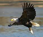
Many of the village children attended a school on the island in the centre of the lake. When they learned that I hailed from South Africa, some children, even those as young as 10 years old, asked questions about president Nelson Mandela and FW de Klerk. And then they instructed me on on their local politics, telling me that the government had banned fishing on certain days to prevent over-utilization of the resource. Boat trips to the intriguing Ol Kokwe island that forms an irregular volcanic mound in the centre of the lake are popular among tourists. Many of the boatmen are virtually dependent on this source of revenue and make an effort to show visitors crocodiles and birds. A common pursuit is to attract fish eagles by throwing out a few tilapia bought from passing Njemps fishermen.
The Njemps are an isolated group of Maasai who now make a living from a combination of fishing, livestock husbandry and tourism. They fish from tiny wooden rafts that they paddle across the lake's waters with their hands, while their feet dangle on either side of the craft into the water.
Although eco-tourism is a vital industry in this arid region, it was apparent that opportunism is causing some strain on the relations between locals and tourists. For example, it is common practice for a boat trip, marketed as a one-hour excursion, to terminate in the middle of the lake. The boatmen then demand additional payment for the return trip. On my boat trip I was continually hounded for donations for science books and geography books. The continued pestering was annoying not just for me but, judging by their reactions, most of my fellow tourists as well.
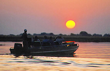
Despite these few irritations, the few days I spent at Lake Baringo were some of the most memorable of the time I spent in Kenya. I particularly enjoyed sunsets down at the lake. A floating platform moored a short distance out into the water permits uninterrupted views over the surface of the lake and the surrounding high walls of the Rift Valley. In Kenya the horizon often appears to be a week's journey away, and this seemed particularly true of the folded range of mountains away to the south-east. Out on the platform, late afternoon light colored the adjacent submerged grasses the color of ripe wheat, contrasting vividly with the dark stormy sky that brooded over the distant highlands.
LAKE TURKANA
North of Lake Baringo, the searing desert of what was once known as the NFD
(Northern Frontier District) still retains much of its frontier ambience.
Small dusty towns, separated by lengthy stretches of open road, provide the
only links with the rest of Kenya. In this remote wasteland, in the period
1952 to 1959, Jomo Kenyatta and his fellow detainees were held at Lokitaung,
975 kilometers from Nairobi on Lake Turkana's western shore.
An estimated 72 per cent of Kenya receives less than 500 millimeters of rain. The village of Wajir receives on average a meager 232 millimeters, and near Lake Turkana rainfall is often half this amount, not much considering that annual evaporation exceeds 2 600 millimeters. Scattered Acacia and Commiphora bushes comprise the vegetation of this sun-scorched region. At times a scant covering of grass grows between the bushes but, during periods of prolonged drought, grass may be absent for years.
In the centre of this inhospitable badland of volcanic rock, Lake Turkana, measuring 250 kilometers in length and covering 6 400 km2, is one of the most intriguing of Kenya's many natural wonders. Lake Turkana is the largest desert lake in the world, and has no outlet. From the Ethiopian highlands, the Omo River flows into the north of the lake and provides most of the lake's inflow. At the point where the Omo enters the lake, a typical bird-foot delta has been formed by sediment-laden water flowing between silt levees before depositing its load. Annual evaporation is estimated at 16 600 million cubic meters and, as inflow is dependent on rainfall, the lake level frequently fluctuates.
There is geological evidence that the lake once extended 200 kilometers further south to Lake Baringo, representing a 150-metre drop in water level. As the system is closed, there is no outlet for the salts carried into the lake by rivers. As a result, the alkaline water tastes much the same as bottled soda water. The dissolved salts color the lake a marine green, and the lake is sometimes known as 'The Jade Sea'.
About eight kilometers north of the village of Loiyangalani, a collection of palm-frond covered huts on a desolate plain of black gravel is the only indication that the visitor has reached the El-Molo's sole village. The El-Molo do not keep livestock, and depend entirely on fishing, occasionally hunting crocodiles and hippos. Numbering only about 500, the El-Molo have been the subject of much curiosity in the past.
It is thought that they migrated to the lakeshore about 2 000 years ago. There has been speculation that the El-Molo derived from the Samburu loo molo onsikirri, 'the people who eat fish' - descended from a Rendile group that was forced to fish after their livestock had perished. Two of the lake's volcanic islands have been declared national parks. On the central island three still-active volcanoes occasionally emit smoke. Large numbers of water birds feed in the shallow waters adjoining the shoreline. The lake harbors one of the largest surviving populations of Nile crocodile in Africa, estimated at more than 10 000. On the eastern lakeshore, the 1 575 km2 Sibiloi National Park protects the rich Koobi Fora fossil beds, and a diverse desert fauna.
On the long road back from Lake Turkana, the Samburu village of South Horr occupies a narrow gap between the peaks of the Nyiru range. The Samburu, dressed in their traditional red attire, transform the stunning scenery to near picture perfect. The Samburu are northern relatives of the Maasai, and Samburu dances are a regular event at South Horr. After leaving South Horr, the road passes through the dusty frontier settlement of Baragoi, then crosses dry savanna plains before finally climbing a long spur to the cedar forests of the highlands near Maralal.
An ocean in the making
How do oceans form and how do continents split apart? Many geologists believe that Kenya's Rift Valley represents a natural laboratory, the study of which might help to answer these questions.
Since the middle of this century, geologists have been refining a theory that describes the dynamic evolution of the Earth through time. This theory of 'plate tectonics' postulates that the Earth's outer layer consists of rigid plates which rotate and move relative to one another, driven by the heat energy of the planet's interior. For hundreds of millions of years, the Earth's continents have been breaking up and re-amalgamating, its ocean basins have grown and shrunk in an excruciatingly slow global dance of gigantic proportions. Oceanic plates grow by volcanic outpourings along a worldwide system of so-called mid-ocean ridges, while old oceanic material is devoured in deep-sea trenches. The East African Rift System, of which the Kenya Rift Valley forms a part, extends for more than 5 500 kilometers from the Afar depression of northern Ethiopia to almost as far south as the mouth of the Zambezi in Mozambique. It is connected to the global network of mid-ocean ridges via the Gulf of Aden and has been volcanically and tectonically active for tens of millions of years. Many geologists believe that this continental rift system, essentially a large crack through the African continent, represents the site of incipient continental break-up.
Where it is best developed, the Kenya Rift Valley is bounded by steep faults - zones of considerable vertical displacement of the Earth's crust. The Rift Valley is a zone of crustal extension in which the African continent has been stretched and thinned by horizontal separation of the crustal blocks on either side of the rift. Beneath the rift, hot, buoyant material from deep within the Earth's mantle is rising, contributing to the thinning of the continental material and initiating the formation of magmas, which may eventually emerge from fissures or volcanic cones at the surface. Volcanism in Kenya started around 30 million years ago in northern Turkana and near the Kenya-Uganda border (for example, Mount Elgon) and progressively migrated towards the south and east. The tectonic development of the rift began with the formation of a shallow basin in northern Kenya, followed by the development of the major boundary faults which define the Rift Valley at present. The most recent volcanic activity has occurred in the Rift Valley itself and at a number of volcanic centers some distance to the east (for example, Mount Kilimanjaro).
Volcanic and tectonic activity in the East African Rift System continues to the present day. If the rifting and extension continue for another several tens of millions of years, the African continent may eventually be torn into two fragments. Seawater would flood the area between them, forming a young ocean basin analogous to the Red Sea which separates Africa from the Arabian Peninsula today.
Any exploration of Kenya's Rift lakes could occupy a week or two, or even three. Personally, I could have spent a few extra days at lakes Nakuru and Bogoria. Any venture to the lakes unveils diverse habitats, ranging from grassland and dense Acacia forest to dry scrubland and pure desert. Many African countries have wide open spaces, game-rich savannas, high mountains and dense forests. But, in my view, and especially for the visitor from southern Africa, Kenya's exquisite array of Rift Valley lakes is the country's distinguishing feature, and its leading tourist attraction.
Kenya Reading
Birding
in Kenya
Exploring Kenya’s
Rift Valley Lakes
Leopard Journal
Kenya: Home of the Safari
---------------------------------------------------
Listening • Understanding •Planning
Introduce Yourself -
Scheduled Trips - Private Safaris
- Newsletter
About Us - Our Mission
- Our Philosophy - Yacht
Charter - DryGoods
![]() We speak English
We speak English
![]() Wir sprechen Deutsch
Wir sprechen Deutsch
![]() On parle français
On parle français
![]() Parliamo italiano
Parliamo italiano
info at vacationtechnician dot com
Thanks for visiting vacationtechnician.com
Friendly•Dependable•Knowledgeable•Experienced
© 1998-2007 vacationtechnician.com All Rights Reserved